MicroGIS forum

Cartographic software package MicroGIS
Текущее время: 19 апр 2024, 01:12

Часовой пояс: UTC + 2 часа


Начать новую тему Ответить на тему  [ Сообщений: 145 ]  На страницу Пред.  1, 2, 3, 4, 5, 6, 7 ... 10  След.
Автор Сообщение
 Заголовок сообщения: Beta testing (discussion of the functional beta version)
СообщениеДобавлено: 14 июн 2012, 20:45 
Не в сети
Администратор
Администратор
Аватара пользователя

Зарегистрирован: 06 фев 2012, 15:57
Сообщения: 1041
Откуда: Украина
Страна: Ukraine (ua)
This topic is a discussion only to the current functional beta versions MicroGIS Editor.

- Before asking a question, please read the FAQ.
- When you have problem with program (access violation, crash, bug, etc.), do not rush just to write on the board. Try to repeat his actions and find a pattern. In this case, the developer fixes the problem quickly.
- In the description of the problem, found bugs, crashes describe your actions step by step. That is so that they could be repeated.
- At the end of the message, include: test version of software, operating system name.
For example: MGE v1.0.5.327b + Win7x64

The actual test period: unlimited.
The latest version of the editor: MicroGISEditor v1.1.15.615 release
Download the latest version of the editor, you can follow the link: http://www.micro-gis.com/index.php/download.html.
Download the latest update editor, you can follow the link: http://www.micro-gis.com/index.php/download.html.
About changes in the latest version, read here: http://www.micro-gis.com/index.php/news.html.
How to install and update software, look here: http://www.micro-gis.com/forum/viewtopic.php?f=1&t=3

In this theme, the use of red color in messages is prohibited.

 Limitations of unregistered version
These functions require the presence of a license:
Loading raster maps ECW and JPEG2000.
Loading images with GPS binding.
Loading altitude terrain data format SRTM.
Export in format SHP.
Export in format DXF.
Work in the group table is limited to 5 objects.
Visualization WEB- card limited scale 240m .
Text search.
Mode of the map in 3D.
3D viewing mode attached models.
Submission address database in tree form .
Working with Multilanguage .
Lock objects of change.
Function selection of map objects according to an arbitrary polygon .
Function selection of map objects by type and intersection.
Clipping function map objects outside the selected site.
Clipping function of map objects within the selected site.
Function to create targeted points in buildings .
HOUSE creation function in buildings .
BUILDING creation function in buildings .
Function cutting all roads in the map at intersections.
Delete function "white" nodes .
Function cutting polygon by polygon.
Polygon feature cutting line.
Function to create points in the polygon of external nodes.
The copy function on the principle objects CorelDraw ( only space).

Note: In future updates of the program , this list may change.

 Registration Program
1. Download and install the latest version of MicroGISEditor.
2. Use the form by typing: Help / About / Activate for copy the computer ID to the clipboard
3. Please register in the online shop: http://shop.micro-gis.com/
4. Specify the computer ID for which you purchase a license
Вложение:
1.jpg
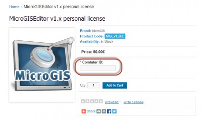
1.jpg [ 70.06 КБ | Просмотров: 125037 ]

5. You will be sent an activation code within 48 hours after confirmation of payment.
6. Use the form by typing: Help / About / Activate to enter your registration information.
Вложение:
2.jpg
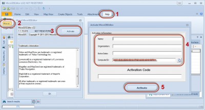
2.jpg [ 170.65 КБ | Просмотров: 125037 ]

7. Restart the application to apply the changes.


Вернуться к началу
 Профиль  
 
 Заголовок сообщения: Re: Beta testing (discussion of the functional beta version)
СообщениеДобавлено: 04 ноя 2012, 06:07 
Не в сети
Администратор
Администратор
Аватара пользователя

Зарегистрирован: 06 фев 2012, 15:57
Сообщения: 1041
Откуда: Украина
Страна: Ukraine (ua)
MicroGIS Editor update v1.0.11.525b
 List of changes:
Version 1.0.11.525 04.11.2012
- Added: to grid, button "Hide not used rows" - when press - will hide all not used rows (rows is not allowed (or with empty value) for all selected on map objects)
- Added to grid: all marine POI's attributes (exclude Facility Point);
- Added new feature: "Highlight buoy color";
- Added new feature: "Highlight buoy light";
- Added: program remember last selected types at "Select By Type" window;
- Added: program remember rows width at list of select type (Object properties panel);
- Added: after change unknown polyline to "Road" type - will auto create nodes and connect to nodes on roads, which crossed new road. (Swith on/off features - at "Properties" window.)
- Changed: at Grid - window of select new type of object may be closed on double click on column;
- Changed: at object properties panel, at column "Floors" - added buttons of increase/decrease of value;
- Changed: paste special symbols (~[0x....]) - available for any types;
- Changed: "snap to grid" properties - default is switch off ;
- Changed: draw selected POI - as draw contour of selected polygon (available for change - at "Properties" window";
- Fixed bug: delete/add time of turn restriction;
- Fixed bug: at feature "Rotate object" - in some case have been error "atan2 domain error";


Вернуться к началу
 Профиль  
 
 Заголовок сообщения: Re: Beta testing (discussion of the functional beta version)
СообщениеДобавлено: 05 ноя 2012, 18:27 
Не в сети
Администратор
Администратор
Аватара пользователя

Зарегистрирован: 06 фев 2012, 15:57
Сообщения: 1041
Откуда: Украина
Страна: Ukraine (ua)
MicroGIS Editor update v1.0.11.526b
 List of changes:
Version 1.0.11.526 05.11.2012
- Changed: colors for types 0x6f, 0xc,0x4
- Fixed bug: value for attribute "LightType" at Object Properties Panel;


Вернуться к началу
 Профиль  
 
 Заголовок сообщения: Re: Beta testing (discussion of the functional beta version)
СообщениеДобавлено: 07 ноя 2012, 21:38 
Не в сети
Администратор
Администратор
Аватара пользователя

Зарегистрирован: 06 фев 2012, 15:57
Сообщения: 1041
Откуда: Украина
Страна: Ukraine (ua)
MicroGIS Editor update v1.0.11.527b
 List of changes:
Версия 1.0.11.527b 07.11.2012
- Added: attributes 3D objects. Objects, which can have 3D attributes additional have :
Model Name - to MP file save with key 3DModelName=###
Model Path - to MP file save with key 3DModelPath=###
Center position, if it changed (for default, position set automatical) to MP file save with key 3DModelPosition=Lat, Lon
- Added: export to MPC ShapeFiles - 3D models information
- Changed: key "Color=" - can have polylines from 0x104xx to 0x106xx, and POI 0x10500
- Changed: key "Style=" - can have polylines from 0x104xx to 0x106xx, and 0x10108
- Fixed: changing unknown type at grid.


Вернуться к началу
 Профиль  
 
 Заголовок сообщения: Re: Beta testing (discussion of the functional beta version)
СообщениеДобавлено: 14 ноя 2012, 20:41 
Не в сети
Администратор
Администратор
Аватара пользователя

Зарегистрирован: 06 фев 2012, 15:57
Сообщения: 1041
Откуда: Украина
Страна: Ukraine (ua)
MicroGIS Editor update v1.0.11.528b
 List of changes:
Version 1.0.11.528b 07.14.2012
- Added : At Object Properties Panel, at row "Path to 3D Model" - second button, for Preview attached 3D - Model
Model MUST BE created as MPC 3D model (see MPC manual - "3D Model Guidelines").
Preview model commands -
- Mouse Left Button Click (at window) -switch on\off texture;
- Mouse Right Button Click (at window) -swith on\off Lighting;
- Keyboard key "Arrow Left\Right" - expidate - reduce - revers rotate of object.

- Changed: At .dbf file extended field for Phone;
- Fixed: export Zip and HGT_DP_FMT attribute to MPC ShapeFiles;


Вернуться к началу
 Профиль  
 
 Заголовок сообщения: Re: Beta testing (discussion of the functional beta version)
СообщениеДобавлено: 16 ноя 2012, 12:58 
Не в сети
Новый пользователь
Новый пользователь

Зарегистрирован: 15 ноя 2012, 17:15
Сообщения: 2
Страна: Spain (es)
This is my first message on this foro, congratulations for the program.
Let m put a couple of questions.
1) Is there available the Trim function ?. This would allow to cut a big map on parts.
2) Is it possible to merge all polylines with a command? Apparently the tool Map object---Merge all objects does not make it.

Kid regards
k2roble


Вернуться к началу
 Профиль  
 
 Заголовок сообщения: Re: Beta testing (discussion of the functional beta version)
СообщениеДобавлено: 16 ноя 2012, 13:17 
Не в сети
Администратор
Администратор
Аватара пользователя

Зарегистрирован: 06 фев 2012, 15:57
Сообщения: 1041
Откуда: Украина
Страна: Ukraine (ua)
k2roble писал(а):
1) Is there available the Trim function ?. This would allow to cut a big map on parts.

Trimming maps available by polygon only
Вложение:
16.11.jpg
16.11.jpg [ 119.63 КБ | Просмотров: 9051 ]

k2roble писал(а):
2) Is it possible to merge all polylines with a command? Apparently the tool Map object---Merge all objects does not make it.

Merge all polylines with a command? Why?
Merge polylines, Join polylines - supported
Вложение:
16.12.jpg
16.12.jpg [ 51.05 КБ | Просмотров: 9051 ]


Вернуться к началу
 Профиль  
 
 Заголовок сообщения: Re: Beta testing (discussion of the functional beta version)
СообщениеДобавлено: 16 ноя 2012, 14:01 
Не в сети
Новый пользователь
Новый пользователь

Зарегистрирован: 15 ноя 2012, 17:15
Сообщения: 2
Страна: Spain (es)
Hi
Trimming maps is useful for a all objects. Sometimes you need to split a map on smaller ones to manage them. This is available on other programas
Merge all polylines is useful for routing maps. Sometimes when you verify with GIS editor a routable maps , one of the type of problems to correct is a high number of blank nodes . That is, nodes without intersection of lines. If you merge them you avoid those nodes . Them to avoid large lines you can use " Split on intersections ".

Thanks for your answer

K2roble


Вернуться к началу
 Профиль  
 
 Заголовок сообщения: Re: Beta testing (discussion of the functional beta version)
СообщениеДобавлено: 16 ноя 2012, 14:38 
Не в сети
Администратор
Администратор
Аватара пользователя

Зарегистрирован: 06 фев 2012, 15:57
Сообщения: 1041
Откуда: Украина
Страна: Ukraine (ua)
It is a tool "Generate Routing Graph" ???


Вернуться к началу
 Профиль  
 
 Заголовок сообщения: Re: Beta testing (discussion of the functional beta version)
СообщениеДобавлено: 17 ноя 2012, 21:00 
Не в сети
Разработчик
Разработчик
Аватара пользователя

Зарегистрирован: 06 фев 2012, 16:00
Сообщения: 922
Откуда: Украина
Страна: Ukraine (ua)
k2roble писал(а):
Hi
Trimming maps is useful for a all objects. Sometimes you need to split a map on smaller ones to manage them. This is available on other programas
Merge all polylines is useful for routing maps. Sometimes when you verify with GIS editor a routable maps , one of the type of problems to correct is a high number of blank nodes . That is, nodes without intersection of lines. If you merge them you avoid those nodes . Them to avoid large lines you can use " Split on intersections ".

Thanks for your answer

K2roble

Ok. No problem.

For slice object there is tool:
Вложение:
1.png
1.png [ 116.63 КБ | Просмотров: 9047 ]


For trim map:
Вложение:
2.png
2.png [ 124.56 КБ | Просмотров: 9047 ]


For Split roads:
Вложение:
3.png
3.png [ 116 КБ | Просмотров: 9047 ]

_________________
Изображение


Вернуться к началу
 Профиль  
 
 Заголовок сообщения: Re: Beta testing (discussion of the functional beta version)
СообщениеДобавлено: 18 ноя 2012, 16:18 
Не в сети
Администратор
Администратор
Аватара пользователя

Зарегистрирован: 06 фев 2012, 15:57
Сообщения: 1041
Откуда: Украина
Страна: Ukraine (ua)
MicroGIS Editor update v1.0.11.529b
 List of changes:
Version 1.0.11.529b 18.11.2012
- Added: attributes "Junction View" (see MPC manual)
At MP file save as:
[Junction View]
Nod=#
JunctionPoints=#,#
JunctionRoads= #,#,#
JunctionParam= s,(a,b,c),(a,b,c).......(a,b,c)
[END-Junction View]
where s - Path to SVG file
а - type
b - ID
с - "Required"
- Added: export to MPC ShapeFiles - "Junction View"
- Changed: View 3D - model:
- Rotate model - Left mouse button - DOWN and move mouse;
- Zoom In/Zoom Out - Mouse Wheel;
- Switch On/Switch Off texture - down SHIFT and click LEFT mose button;
- Changed: remove attribute "Model Name"
- Changed: export buildings witch had 3D model to MPC ShapeFile - in files "building";


Вернуться к началу
 Профиль  
 
 Заголовок сообщения: Re: Beta testing (discussion of the functional beta version)
СообщениеДобавлено: 19 ноя 2012, 18:23 
Не в сети
Администратор
Администратор
Аватара пользователя

Зарегистрирован: 06 фев 2012, 15:57
Сообщения: 1041
Откуда: Украина
Страна: Ukraine (ua)
MicroGIS Editor update v1.0.11.530b
 List of changes:
Version 1.0.11.530b 19.11.2012
- Added: export to MPC ShapeFiles 3D - NOD level (see MPC manual);
- Changed: at typeset "Garmin" - available set 3D - level for NOD;
- Changed: at typeset "Garmin" - available in mode "Show 3D Map" - 3D Level of Nod.
- Changed: at typeset "Garmin" - available mode "Highliting 3D - Level of Nod".
- Changed: at typeset "Garmin" - when loaded TYP file and defined string "StringMPCName=0x04,###" - the string willbe used for defined MPC Name, and
will be used for export to MPC SgapeFile. For example : StringMPCName=0x04,CUSTOMIZABLE_AREA_224


Вернуться к началу
 Профиль  
 
 Заголовок сообщения: Re: Beta testing (discussion of the functional beta version)
СообщениеДобавлено: 20 ноя 2012, 16:42 
Не в сети
Администратор
Администратор
Аватара пользователя

Зарегистрирован: 06 фев 2012, 15:57
Сообщения: 1041
Откуда: Украина
Страна: Ukraine (ua)
MicroGIS Editor update v1.0.11.531b
 List of changes:
Version 1.0.11.531b 20.11.2012
- Fixed: At Grid - Fill text fields, when first object have a blank value;
- Fixed: At Grid - Hide columns (which have value) "Descriptions", when down button "Hide not Used" ;
- Fixed: Set Blank value for "LegalSpeed";


Вернуться к началу
 Профиль  
 
 Заголовок сообщения: Re: Beta testing (discussion of the functional beta version)
СообщениеДобавлено: 30 ноя 2012, 14:01 
Не в сети
Администратор
Администратор
Аватара пользователя

Зарегистрирован: 06 фев 2012, 15:57
Сообщения: 1041
Откуда: Украина
Страна: Ukraine (ua)
Attention, extended testing period MicroGISEditor till 31.12.2012


Вернуться к началу
 Профиль  
 
 Заголовок сообщения: Re: Beta testing (discussion of the functional beta version)
СообщениеДобавлено: 30 ноя 2012, 22:43 
Не в сети
Администратор
Администратор
Аватара пользователя

Зарегистрирован: 06 фев 2012, 15:57
Сообщения: 1041
Откуда: Украина
Страна: Ukraine (ua)
MicroGIS Editor update v1.0.11.532b
 List of changes:
Version 1.0.11.532b 30.11.2012
- Changed: Algorithmes of read, work, and save position coordinates;
- Changed: For 25 and 26 bits - avialable function "snap to grid", if set at options;
- Added: Typesets "Topo" and "Garmin" - extended till 28 bits;
- Added: Save position coordinates with 27 and 28 bytes will make with precision 7 digitals after point;
- Added: Maximum zoom - 1 meter;
- Fixed: work with extras at grid;


Вернуться к началу
 Профиль  
 
 Заголовок сообщения: Re: Beta testing (discussion of the functional beta version)
СообщениеДобавлено: 02 дек 2012, 21:12 
Не в сети
Администратор
Администратор
Аватара пользователя

Зарегистрирован: 06 фев 2012, 15:57
Сообщения: 1041
Откуда: Украина
Страна: Ukraine (ua)
MicroGIS Editor update v1.0.11.533b
 List of changes:
Version 1.0.11.533b 02.12.2012
- Added new feature: at mode "Select Object" - in Context Menu new command - "Export to DFX" - will make DFX file for create new 3D model, and XML file with position future 3D model (required for CityGuide, not required for Garmin);
- Changed: for create GRMN_TYPE from TYP file will use string: StringX = 0x64, ##### (GRMN_TYPE);


Вернуться к началу
 Профиль  
 
Показать сообщения за:  Поле сортировки  
Начать новую тему Ответить на тему  [ Сообщений: 145 ]  На страницу Пред.  1, 2, 3, 4, 5, 6, 7 ... 10  След.

Часовой пояс: UTC + 2 часа


Кто сейчас на конференции

Сейчас этот форум просматривают: нет зарегистрированных пользователей и гости: 1


Вы не можете начинать темы
Вы не можете отвечать на сообщения
Вы не можете редактировать свои сообщения
Вы не можете удалять свои сообщения
Вы не можете добавлять вложения

Найти:
Перейти:  
cron
Powered by phpBB® Forum Software © phpBB Group
Русская поддержка phpBB