MicroGIS forum

Cartographic software package MicroGIS
Текущее время: 19 апр 2024, 20:38

Часовой пояс: UTC + 2 часа


Начать новую тему Ответить на тему  [ Сообщений: 145 ]  На страницу Пред.  1 ... 3, 4, 5, 6, 7, 8, 9, 10  След.
Автор Сообщение
 Заголовок сообщения: Beta testing (discussion of the functional beta version)
СообщениеДобавлено: 14 июн 2012, 20:45 
Не в сети
Администратор
Администратор
Аватара пользователя

Зарегистрирован: 06 фев 2012, 15:57
Сообщения: 1041
Откуда: Украина
Страна: Ukraine (ua)
This topic is a discussion only to the current functional beta versions MicroGIS Editor.

- Before asking a question, please read the FAQ.
- When you have problem with program (access violation, crash, bug, etc.), do not rush just to write on the board. Try to repeat his actions and find a pattern. In this case, the developer fixes the problem quickly.
- In the description of the problem, found bugs, crashes describe your actions step by step. That is so that they could be repeated.
- At the end of the message, include: test version of software, operating system name.
For example: MGE v1.0.5.327b + Win7x64

The actual test period: unlimited.
The latest version of the editor: MicroGISEditor v1.1.15.615 release
Download the latest version of the editor, you can follow the link: http://www.micro-gis.com/index.php/download.html.
Download the latest update editor, you can follow the link: http://www.micro-gis.com/index.php/download.html.
About changes in the latest version, read here: http://www.micro-gis.com/index.php/news.html.
How to install and update software, look here: http://www.micro-gis.com/forum/viewtopic.php?f=1&t=3

In this theme, the use of red color in messages is prohibited.

 Limitations of unregistered version
These functions require the presence of a license:
Loading raster maps ECW and JPEG2000.
Loading images with GPS binding.
Loading altitude terrain data format SRTM.
Export in format SHP.
Export in format DXF.
Work in the group table is limited to 5 objects.
Visualization WEB- card limited scale 240m .
Text search.
Mode of the map in 3D.
3D viewing mode attached models.
Submission address database in tree form .
Working with Multilanguage .
Lock objects of change.
Function selection of map objects according to an arbitrary polygon .
Function selection of map objects by type and intersection.
Clipping function map objects outside the selected site.
Clipping function of map objects within the selected site.
Function to create targeted points in buildings .
HOUSE creation function in buildings .
BUILDING creation function in buildings .
Function cutting all roads in the map at intersections.
Delete function "white" nodes .
Function cutting polygon by polygon.
Polygon feature cutting line.
Function to create points in the polygon of external nodes.
The copy function on the principle objects CorelDraw ( only space).

Note: In future updates of the program , this list may change.

 Registration Program
1. Download and install the latest version of MicroGISEditor.
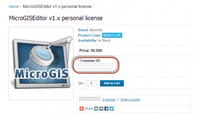
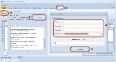
2. Use the form by typing: Help / About / Activate for copy the computer ID to the clipboard
3. Please register in the online shop: http://shop.micro-gis.com/
4. Specify the computer ID for which you purchase a license
Вложение:
1.jpg
1.jpg [ 70.06 КБ | Просмотров: 125641 ]

5. You will be sent an activation code within 48 hours after confirmation of payment.
6. Use the form by typing: Help / About / Activate to enter your registration information.
Вложение:
2.jpg
2.jpg [ 170.65 КБ | Просмотров: 125641 ]

7. Restart the application to apply the changes.


Вернуться к началу
 Профиль  
 
 Заголовок сообщения: Re: Beta testing (discussion of the functional beta version)
СообщениеДобавлено: 25 янв 2013, 20:48 
Не в сети
Администратор
Администратор
Аватара пользователя

Зарегистрирован: 06 фев 2012, 15:57
Сообщения: 1041
Откуда: Украина
Страна: Ukraine (ua)
MicroGISEditor update v1.0.11.548b
 List of changes:
Version 1.0.11.548b 25.01.2013
- Added: at Map Properties, in tab "cGpsMapper" - properties "Marine Map", at header of file MP, save with key "Marine=Y" (see manual cGpsMapper);
- Added: ignore case sensitvie for special sumbols ~[0x1c], ~[0x1e],~[0x1f];
- Added: for
1) Polylines:
0x20 MINOR_CONTOUR
0x21 INT_CONTOUR
0x22 MAJOR_CONTOUR
0x23 MINOR_BATHY_CONTOUR
0x24 INT_BATHY_CONTOUR
0x25 MAJOR_BATHY_CONTOUR
2) POI's:
0x6300 SPOT_ELEVATION
0x6200 SPOT_SOUNDING
export to MPC ShapeFiles and set at Map Properties Elevation in meters will be automatical change to feets;
- Change: in mode of edit nodes : colors for nodes: first one - silver, second one - grey, next all - black;
- Added: to context menu in mode "Edit Nodes" - command "Reverse nodes" (for polygons only);
- Added: to context menu in mode "Edit Nodes" - command "Set Node As First" (for polygons only);
- Added: when select polyline - will be show dir indicator;
- Added: enable feature "Show Direction" for any polylines;


Вернуться к началу
 Профиль  
 
 Заголовок сообщения: Re: Beta testing (discussion of the functional beta version)
СообщениеДобавлено: 29 янв 2013, 20:14 
Не в сети
Администратор
Администратор
Аватара пользователя

Зарегистрирован: 06 фев 2012, 15:57
Сообщения: 1041
Откуда: Украина
Страна: Ukraine (ua)
MicroGISEditor update v1.0.11.549b
 List of changes:
Version1.0.11.549 29.01.2013
- Changed: GPX Loader - for decrease time of load;
- Fixed: show on map and covert for(to) meters, feets special sumbol ~[0x1f];
- Fixed: export to MPC ShapeFiles Roads, whith have LaneAssist and Junction Views;
- Added: at Window of Edit Points - status bar with caret position;


Вернуться к началу
 Профиль  
 
 Заголовок сообщения: Re: Beta testing (discussion of the functional beta version)
СообщениеДобавлено: 30 янв 2013, 16:57 
Не в сети
Администратор
Администратор
Аватара пользователя

Зарегистрирован: 06 фев 2012, 15:57
Сообщения: 1041
Откуда: Украина
Страна: Ukraine (ua)
MicroGISEditor update v1.0.11.550b
 List of changes:
Version 1.0.11.550b 30.01.2013
- Added: at window "Attached Files" - button "Remove" - for remove file from map and disk;
- Added: at mode "Select Points" - enable move POI;
- Added: when select any polugon contour line will be with arrow - whith show direction of nodes;
- Changed: at mode "Select Points" - only firs point have a diffirent color (Silver).


Вернуться к началу
 Профиль  
 
 Заголовок сообщения: Re: Beta testing (discussion of the functional beta version)
СообщениеДобавлено: 31 янв 2013, 21:48 
Не в сети
Администратор
Администратор
Аватара пользователя

Зарегистрирован: 06 фев 2012, 15:57
Сообщения: 1041
Откуда: Украина
Страна: Ukraine (ua)
MicroGISEditor update v1.0.11.551b
 List of changes:
Version 1.0.11.551b 31.01.2013
- Added: When create new road will be crate first and last node (when set in Options);
- Added: Find Type By Description (At Object Properties Panel) set as SUBSTRING;
- Added: Button at Toolbar of Object Properties Panel - "Find Next" - for continue find type by description;
- Added: Export to MPC ShapeFile will with auto convert meters to feet's for POI from 0x6400 to 0x66ff;
- Added: New mode for vertex of objects in mode "Edit Nodes" - "Diamond";
- Added: At Options available change colors for vertex in mode "Edit Nodes".


Вернуться к началу
 Профиль  
 
 Заголовок сообщения: Re: Beta testing (discussion of the functional beta version)
СообщениеДобавлено: 07 фев 2013, 15:17 
Не в сети
Администратор
Администратор
Аватара пользователя

Зарегистрирован: 06 фев 2012, 15:57
Сообщения: 1041
Откуда: Украина
Страна: Ukraine (ua)
MicroGISEditor update v1.0.11.552b
 List of changes:
Version 1.0.11.552b 07.02.2013
- Added: finf road by ID. Available at second tab window "Find objects";
- Added: new menu for auto create addresses for new building - "Do Not Increment" - for create and change label in building with house number = "46/7" or "46 corp. 2";
- Changed: find street in city - will find by substringand will appear only included input substring;
- Changed: numbers along road may have in addresses symbol "(" or ")".


Вернуться к началу
 Профиль  
 
 Заголовок сообщения: Re: Beta testing (discussion of the functional beta version)
СообщениеДобавлено: 08 фев 2013, 21:31 
Не в сети
Администратор
Администратор
Аватара пользователя

Зарегистрирован: 06 фев 2012, 15:57
Сообщения: 1041
Откуда: Украина
Страна: Ukraine (ua)
MicroGISEditor update v1.0.11.553b
 List of changes:
Version 1.0.11.553b 08.02.2013
- Changed: Draw lane connection - new mode "draw connect abeam lane" . This mode set as default;
- Added: new feature "Highlight marine lines by polygon side" - avialable at tab "Map View". Lines highliting:
a) no side - black;
b) right side - red;
c) left side - green;
d) both side - dark yellow;
Note: not work if swith on "Highlight road class" or "Highlight by address";
- Added: new feature "Auto copy from StreetDesc to Label" - when on (for default off) at Option (edit), and select Street for road will make copy name of street to Label.


Вернуться к началу
 Профиль  
 
 Заголовок сообщения: Re: Beta testing (discussion of the functional beta version)
СообщениеДобавлено: 12 фев 2013, 12:49 
Не в сети
Администратор
Администратор
Аватара пользователя

Зарегистрирован: 06 фев 2012, 15:57
Сообщения: 1041
Откуда: Украина
Страна: Ukraine (ua)
MicroGISEditor update v1.0.11.554b
 List of changes:
Version 1.0.11.554b 11.02.2013
- Added: Add to map - CityGuide BKM file (for POI ONLY!!!) - for testing. POI which will be added have comments "Imported" - for filter and check;
- Program compiled with new version of component, that is required change library;


Вернуться к началу
 Профиль  
 
 Заголовок сообщения: Re: Beta testing (discussion of the functional beta version)
СообщениеДобавлено: 12 фев 2013, 23:43 
Не в сети
Администратор
Администратор
Аватара пользователя

Зарегистрирован: 06 фев 2012, 15:57
Сообщения: 1041
Откуда: Украина
Страна: Ukraine (ua)
MicroGISEditor update v1.0.11.555b
 List of changes:
Version 1.0.11.555b 12.02.2013
- Added: Import BKM file CityGuide (POI, Radars, Road Signs).


Вернуться к началу
 Профиль  
 
 Заголовок сообщения: Re: Beta testing (discussion of the functional beta version)
СообщениеДобавлено: 14 фев 2013, 18:15 
Не в сети
Администратор
Администратор
Аватара пользователя

Зарегистрирован: 06 фев 2012, 15:57
Сообщения: 1041
Откуда: Украина
Страна: Ukraine (ua)
MicroGISEditor update v1.0.11.556b
 List of changes:
Version 1.0.11.556b 14.02.2013
- Fixed: import from City Guide BKM file;
- Added: export to CityGuide BKM file (POI ONLY);
- Added: wizard for export to BKM File.


Вернуться к началу
 Профиль  
 
 Заголовок сообщения: Re: Beta testing (discussion of the functional beta version)
СообщениеДобавлено: 16 фев 2013, 12:27 
Не в сети
Администратор
Администратор
Аватара пользователя

Зарегистрирован: 06 фев 2012, 15:57
Сообщения: 1041
Откуда: Украина
Страна: Ukraine (ua)
MicroGISEditor update v1.0.11.557b
 List of changes:
Version 1.0.11.557b 15.02.2013
- Added: export to City Guide BKM file Road Signs and Radars (Speed Cams);
- Changed: - Draw Selected Road Sign And Speed Cam (Radar);
- Changed: when not found attached file - message will output to Message Log.


Вернуться к началу
 Профиль  
 
 Заголовок сообщения: Re: Beta testing (discussion of the functional beta version)
СообщениеДобавлено: 16 фев 2013, 20:32 
Не в сети
Администратор
Администратор
Аватара пользователя

Зарегистрирован: 06 фев 2012, 15:57
Сообщения: 1041
Откуда: Украина
Страна: Ukraine (ua)
MicroGISEditor update v1.0.11.558b
 List of changes:
Version 1.0.11.558b 16.02.2013
- Added: at mode "Highlight marine lines by polygon side" - Direction indicaror for lines;
- Added: autocopy House Number to Label; Available at "Options" - for default - swith of;
- Fixed: for CityGuide type 18957 - undocumentation export to City Guide BKM file;
- Fixed: set direction indicator for marine lines.


Вернуться к началу
 Профиль  
 
 Заголовок сообщения: Re: Beta testing (discussion of the functional beta version)
СообщениеДобавлено: 18 фев 2013, 01:33 
Не в сети
Администратор
Администратор
Аватара пользователя

Зарегистрирован: 06 фев 2012, 15:57
Сообщения: 1041
Откуда: Украина
Страна: Ukraine (ua)
MicroGISEditor update v1.0.11.559b
 List of changes:
Version 1.0.11.559 17.02.2013
- Added: add/change/remove directions of road signs and radars;


Вернуться к началу
 Профиль  
 
 Заголовок сообщения: Re: Beta testing (discussion of the functional beta version)
СообщениеДобавлено: 19 фев 2013, 16:52 
Не в сети
Администратор
Администратор
Аватара пользователя

Зарегистрирован: 06 фев 2012, 15:57
Сообщения: 1041
Откуда: Украина
Страна: Ukraine (ua)
MicroGISEditor update v1.0.11.560b
 List of changes:
Version 1.0.11.560b 19.02.2013
- Changed: select direction of RoadSign and Entry Point of object, when position of object (road sign) out of screen;
- Added: on create new road, for new road automatical apply Route Params, according settings, if it switch on at "Options";
- Added: on create new road, for roads automatical will create routing nodes at intersections, if it switch on at "Options";
- Added: at window "Find" - button "Ok" - set as default (will be press on "Enter") ;
- Added: after paste copied coordinates at box of coordinates, available press "Enter" for show position;
- Added: at mode "Edit Nodes" - at context menu command "Copy Coordinates" - for copy coordinates to clipboard (as text).


Вернуться к началу
 Профиль  
 
 Заголовок сообщения: Re: Beta testing (discussion of the functional beta version)
СообщениеДобавлено: 22 фев 2013, 00:49 
Не в сети
Администратор
Администратор
Аватара пользователя

Зарегистрирован: 06 фев 2012, 15:57
Сообщения: 1041
Откуда: Украина
Страна: Ukraine (ua)
MicroGISEditor update v1.0.11.561b
 List of changes:
Version 1.0.11.561b 21.02.2013
- Added: when copy object by CorelDraw rule - if object - building , will increment House Number, if it set up at "Options";
- Added: remember last mode of Editor;
- Added: At mode "Edit Nodes" - command "Select All Vertex";
- Added: At mode "Edit Nodes" command "Split Polygon By Polyline";
Rules:
1. After activate can make polyline;
2. Polyline MUST cross selected polygon;
3. Exit from ,this mode - after split polygon or press right muse button or press ESC key;
4. If polyline NOT CROSS Polygon - split is unavailable;


Вернуться к началу
 Профиль  
 
 Заголовок сообщения: Re: Beta testing (discussion of the functional beta version)
СообщениеДобавлено: 27 фев 2013, 00:25 
Не в сети
Администратор
Администратор
Аватара пользователя

Зарегистрирован: 06 фев 2012, 15:57
Сообщения: 1041
Откуда: Украина
Страна: Ukraine (ua)
MicroGISEditor update v1.0.11.562b
 List of changes:
Version 1.0.11.562b 26.02.2013
- Added to all tools and "Options" change road class and speed limit for next Garmin types:
0x0d CUSTOMIZABLE_ROUTE_LINE_1
0x0e CUSTOMIZABLE_ROUTE_LINE_2
0x0f CUSTOMIZABLE_ROUTE_LINE_3
0x10 CUSTOMIZABLE_ROUTE_LINE_4
0x11 CUSTOMIZABLE_ROUTE_LINE_5
0x12 CUSTOMIZABLE_ROUTE_LINE_6
0x13 CUSTOMIZABLE_ROUTE_LINE_7
- Changed: tool "Split Polygon By Line" will work if line connected to vertex or contour of polygon;
- Changed: toll "Split Polygon By Line" - correct work with elements of polygon;
- Fixed all found bags;


Вернуться к началу
 Профиль  
 
Показать сообщения за:  Поле сортировки  
Начать новую тему Ответить на тему  [ Сообщений: 145 ]  На страницу Пред.  1 ... 3, 4, 5, 6, 7, 8, 9, 10  След.

Часовой пояс: UTC + 2 часа


Кто сейчас на конференции

Сейчас этот форум просматривают: нет зарегистрированных пользователей и гости: 1


Вы не можете начинать темы
Вы не можете отвечать на сообщения
Вы не можете редактировать свои сообщения
Вы не можете удалять свои сообщения
Вы не можете добавлять вложения

Найти:
Перейти:  
Powered by phpBB® Forum Software © phpBB Group
Русская поддержка phpBB